Gruncharitsa Project - Position and Geology

Metallogenic Belts of SE Europe

Tungsten Mineralization in Bulgaria

  • Gruncharitsa is the only known Tungsten mineralization of its kind in Bulgaria
  • The first to be put in production in SE Europe

Regional Position and Regional Geology

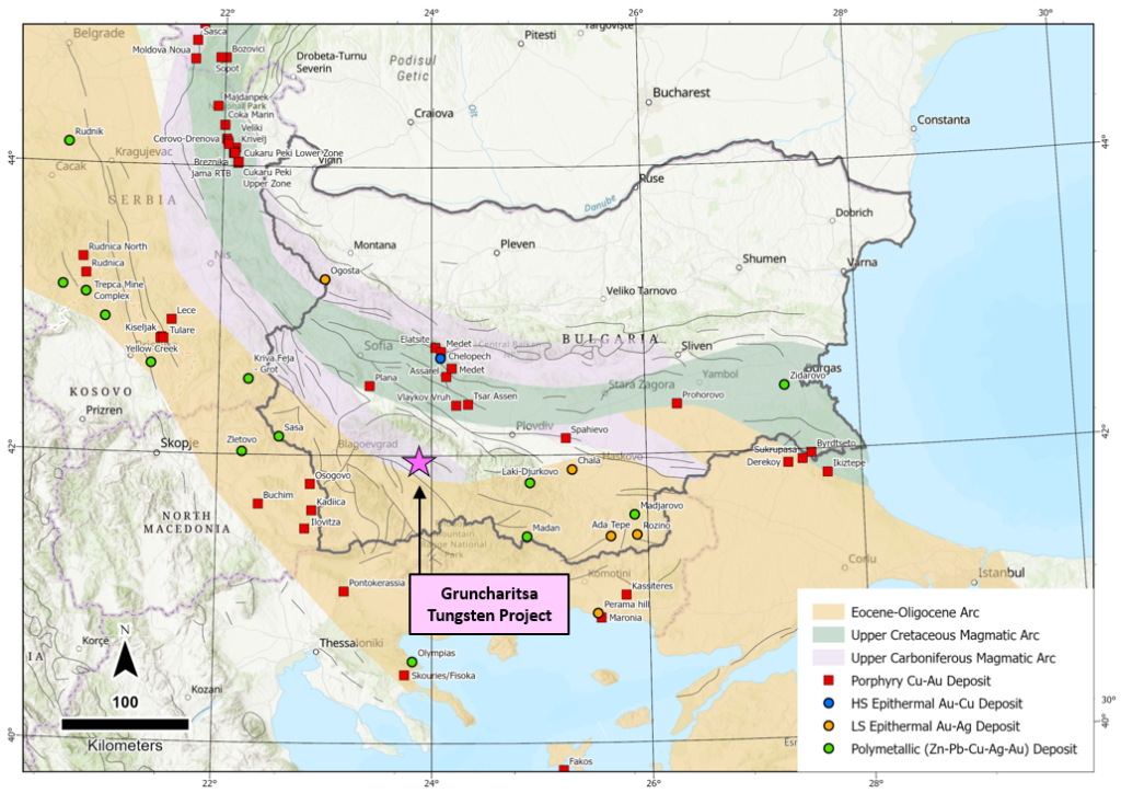
Variscan (Upper Carboniferous 370-290Ma) Magmatic Arc in Western Rhodope, as segment of the well known Tethyan Metallogeny Belt of Europe (Porphyry Cu-Au and Epithermal Au-Ag belt)

The Variscan magmatic arc is built of Precambrian basement rocks consist of metamorphic rocks (marble, gneiss, granite gneiss, amphibolites, marble and schist) intruded by granitic batholites and intrusive bodies of Paleozoic age

Regionally the same Variscan magmatic arc extends from Czech Republic, through central Bulgaria and further east to Kazakhstan and south Mongolia
That belt is developed along the active continental margin of the Eurasia continent characterized by a number of reduced gold and tungsten bearing hydrothermal systems that produced some of the world class gold deposits (Czech Republic, Bulgaria and Kazakhstan) associated with many tungsten and molly manifestations in Slovakia, Austria and Bulgaria

Gruncharitsa Project Geology

Variscan Magmatic Rocks

  • Gruncharitsa Granodiorite with widespread pegmatite and aplite

Gruncharitsa Ore Field Occurrences

  • W (Gruncharitsa), Mo-W, Pb-Zn-Cu and Mo-Ag-Au-Bi (Babyak)

Regional Shear Zone

  • Ductile E-W thrust zone – Babyak-Grashevo Shear Zone

Gruncharitsa Deposit Type

  • Intrusion Related Vein Scheelite-Sulphide type spatially related to IR Gold and Mo-Bi porphyries

Hydrothermal alteration and Mineralization

  • Quartz-Scheelite-Sulphide veins and linear stockworks associated with silica-muscovite-k-feldspar-chlorite alteration
  • The Tungsten mineralization is traced over 3.5km along the east-west strike and up to 800m down dip with true width of about 100m

Only 800x500m segment of the prospective tungsten trend is explored in details - Gruncharitsa Center Area. The rest of the mineralized trend requires additional exploration…

Gruncharitsa Project Historical Exploration

Historical Exploration: State Company 1977-1988

  • Geology mapping, soil sampling, trenches, drilling and some underground exploration works
  • 157 drill holes totalling 41 015m – Central Area

Modern Exploration: Resurs 1 AD 2003-2006

  • Regional stream sediment sampling, soil sampling, rock-chip sampling, geological mapping, trenching and core drilling
  • 16 drill holes totalling 3 747m – Central Area

Gruncharitsa Project Drill Core Photographs

Verification Drill Hole 401 (completed 2004)

  • Mineralized Zone 17.50m@0.52% WO3 (158.00 to 175.50m)